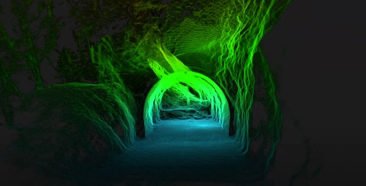
A road tunnel in the Swiss Alps suffered a massive landslide, severing access to a village and disrupting the nearby ski resort. The Elios 3 drone played a crucial role in examining the collapsed tunnel and helping authorities devise a safe course of action. Safety Given the instability of the tunnel, it was impossible to enter safely. The local authorities relied on the Elios 3 to gain situational awareness without risking lives. Efficiency The Elios 3 was swiftly deployed and captured both LiDAR and visual data simultaneously, aiding in problem assessment and response planning. Analysis The point cloud datasets from the Elios 3's LiDAR scan gave authorities a clear visualization of the tunnel’s interior and exterior, highlighting where the landslide originated and its path. Speed The rapid response thanks to the drone ensured repair work commenced quickly, with the tunnel reopening in June of the same year, minimizing traffic disruptions ahead of the summer season. Landslides happen daily across the globe, ranging from mild to catastrophic. They’re often triggered by the shape of the mountain face and worsened by human activities like deforestation and construction. Climate change is another significant factor. Switzerland experiences a spike in landslides in early spring when changing weather makes it easier for materials to dislodge and cascade down. On the evening of February 3, 2024, multiple landslides occurred in the Riddes Valley, Switzerland. One of the road tunnels linking Riddes and La Tzoumaz partially collapsed, restricting access between the villages and cutting off portions of a popular ski resort. Each day the tunnel remained closed posed challenges for locals and tourists alike, forcing them to take longer detours. Knowing how long the tunnel would stay closed was essential for updating those affected on the duration of the disruption. Access to the tunnel was extremely hazardous, making entry nearly impossible. Yet, getting immediate information about the situation was crucial to figure out how to fix the tunnel and proceed with subsequent actions. In the heart of the Alps, local authorities sought innovative solutions to uncover the truth. The landslide happened in the Canton of Valais. Authorities needed to understand the cause of the landslide and its impact on the road tunnel, as well as why the tunnel was so severely affected. A thorough investigation would provide insight into why this happened and improve methods for predicting and mitigating future landslide impacts. Due to the instability of the site, entering the tunnel was not feasible. A remote survey was the only viable option to gather results quickly. Thus, the Valais authorities used the Elios 3 drone with its Surveying Payload to assist their investigations. Their goal was to capture photos, videos, and a LiDAR point cloud of the tunnel to get a comprehensive view of the conditions inside and identify the cause of the collapse. The findings would later be used to plan repair work and contribute to research on similar natural disasters. This project was undertaken by the Department de la Mobilité du Territoire et de l’Environnement, a division of the Valais state authorities. Since the infrastructure is owned by the Canton of Valais, no external parties were involved in the investigation phase. The road tunnel has been around for several decades, and its design is thought to have contributed to its collapse. Inside the tunnel’s outer wall, there was a small window that let in natural light, created during construction. While it provided light and ventilation, it likely didn’t serve any technical purpose. Over time, this window compromised the tunnel's structural integrity. Within 24 hours of the incident, the drone pilot from the Valais authorities planned the mission. The rock surrounding the window and its vicinity quickly became the focal point of the investigation. Multiple flights were conducted with the Elios 3 to collect data. The visual feed from the Elios 3 revealed how the landslide caused the tunnel roof to collapse. The initial flights aimed to map the layout of the rocks, assess the damage to the tunnel, and provide general situational awareness to plan the clearing of the space to reopen the wall. Here, the primary data collected was LiDAR surveys. Further flights focused on studying the window and its potential role in weakening the tunnel. The emphasis in these flights was capturing detailed photos and videos for analysis.  The images captured by the Elios 3 exposed the true extent of the situation – revealing that this accident had been brewing over time. When the tunnel was built in the 1960s, the window was left open. This cold airflow intensified freeze-thaw weathering, causing cracks and faults over time. Additionally, the window itself was structurally weak due to damage to the longitudinal and transverse forces on the gap. It’s also suspected that explosives were used during the tunnel’s excavation. This can lead to decompression in the rock mass, potentially weakening the outer walls exposed to open air. Clear visualization: the LiDAR scan clearly shows the layout of the collapsed tunnel section and where the rocks came through Over the years, the rock around the window developed faults that were progressively weakened by weathering, traffic vibrations, and minor seismic events since the 1960s. By 2023, the rock had grown significantly weaker. There were signs of instability in late 2023. In December 2023, a small rockfall affected the tunnel and the wall outside the window, followed by a second event that same month. These incidents likely thinned the rock pillar separating the tunnel from the surface, reducing the vault effect and continuously weakening stability. Without the Elios 3 in this scenario, accessing and investigating the accident would have been extremely challenging. Sending people inside was not an option, requiring teams to secure the landslide area first to prevent any potential movement before any data collection could begin. This would have slowed down recovery efforts, prolonging the limited access to the tunnel and the villages beyond it. The fly-through of the LiDAR scan shows the full extent of the damage The use of the Elios drone in this case was transformative. Investigators were able to access the affected tunnel the day after the incident, achieving a rapid response. In the past, a landslide might have taken days or even months to fully secure before investigators could approach. Remote access via drones saved countless hours of work and minimized the size of the team required, allowing information to be gathered quickly. By leveraging innovative technology focused on safety, the Valais authorities swiftly gathered critical data while keeping all investigators safe. The geological findings will be incorporated into repair work at this tunnel and future investigations in the region – and this is crucial as changing climates increase the likelihood of unpredictable geological events.
U&C Channel steel is a long strip of steel with a groove-shaped cross-section. Its specifications are expressed in millimeters of waist height (h) * leg width (b) * waist thickness (d), such as 120*60*5.5, which means that the channel steel with a waist height of 120 mm and a leg width of 60 mm has a waist thickness of 5.5 mm. mm channel steel, or UPE120 channel steel.
Channel steel has a wide range of uses and can be used in construction, machinery manufacturing, automobile manufacturing, shipbuilding and other fields. In the field of construction, channel steel is often used to make steel structure frames, support frames, beams and columns, etc. In the field of machinery manufacturing, channel steel is often used to make machine tool beds, tracks, conveyor belts, etc. In the field of automobile manufacturing, channel steel is often used to make frame, body and so on. In the field of shipbuilding, channel steel is often used to make hull frames, ship equipment, etc.
Mild steel channel is widely used in civil engineering and construction to support floor joists and to weight bear above window and door gaps where the structural load does not require an I beam.
C Channel Steel,Hat Channel Steel,Galvanised Steel Channel Tianjin YF Steel Co., Ltd , https://www.youfametal.comExploring a Collapsed Tunnel Following a Landslide in the Swiss Alps
Key Benefits at a Glance
A Landslide in the Swiss Alps
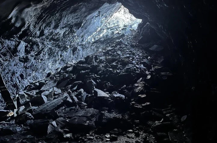 The interior of the tunnel was covered in debris. Image credit: Canton Valais
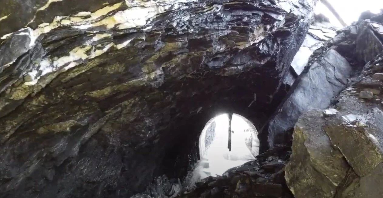
Planning a Landslide Investigation with Drones
Flying a Drone in a Collapsed Tunnel
Insights from Drone Surveys in the Collapsed Tunnel
The Impact of Drones in Emergency Response